


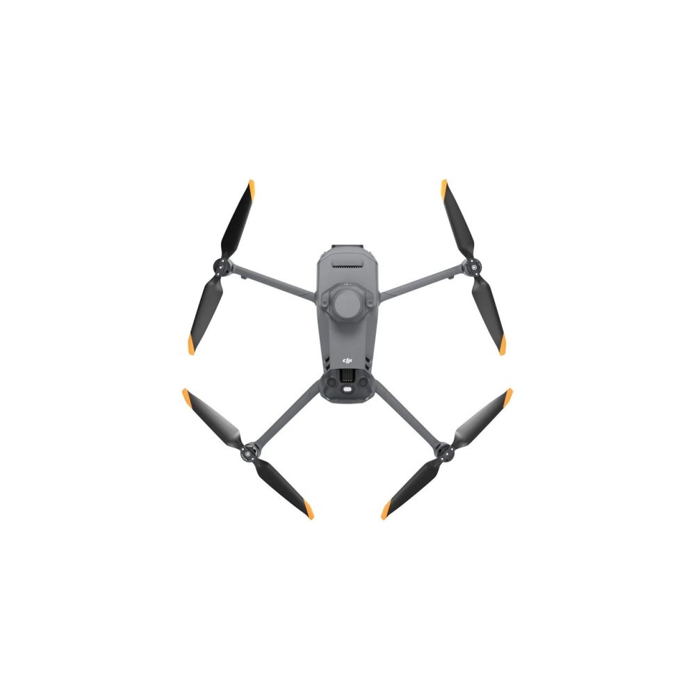
DJI Mavic 3 Multispectral (Universal Edition)


Effective aerial surveys need to see the unseen. That's why the DJI Mavic 3 Multispectral (Universal Edition) has two forms of vision. It combines an RGB camera with a multispectral camera to digitise and analyse culture growth with full clarity.
3,999.-
This product is purchased exclusively for you.
Effective aerial surveys need to see the unseen. That's why the DJI Mavic 3 Multispectral (Universal Edition) has two forms of vision. It combines an RGB camera with a multispectral camera to digitise and analyse culture growth with full clarity.
Reviews
Description
DJI Mavic 3 Multispectral (Universal Edition)
Effective aerial research needs to see the unseen. That's why the DJI Mavic 3 Multispectral (Universal Edition) has two forms of vision. It combines an RGB camera with a multispectral camera to digitise and analyse culture growth with complete clarity. Managing agricultural production requires accuracy and data, and Mavic 3M provides both.
Accurate images that capture every pixel. Mavic 3M with RTK module for centimetre-level positioning. The flight controller, camera and RTK module are synchronised in microseconds to accurately capture the location of each camera's image centre. This allows the Mavic 3M to make highly accurate aerial lifts without using ground control points.
A single flight can complete mapping operations over an area of 200 hectares. The O3 transmission integrates two transmission signals and four receive signals to support ultra-long transmission distances of 15 km.
The drone has several wide field-of-view sensors that accurately detect obstacles in all directions to avoid omnidirectional obstacles. Aerial survey of the field can be easily performed in steep slope landscapes.
The Mavic 3M makes it possible to view the area of orchards even on rolling terrain. Together with DJI Terra or DJI SmartFarm Platform to convert high-resolution orchard maps, automatically identify the number of trees, distinguish trees from other obstacles or objects and generate three-dimensional operating routes for agricultural drones, making operations safer and more efficient.
For fertilising rice, regulating cotton growth and spraying potato leaf fertiliser, Mavic 3M is used to obtain multispectral images of crops. The DJI Terra or the DJI SmartFarm platform can generate NDVI and other vegetation index maps, capture differences in crop potential and generate prescription maps.
The Mavic 3M can perform automatic field recognition. Field recognition images can be posted to the DJI SmartFarm platform in real time over a 4G network. It can find anomalies such as emergency shortages, weed pressure and gardening in a timely manner. It can also perform smart analytics, such as identifying cotton seedlings and rice production trials, using AI identification for real-time sharing of crop growth information, agronomic activity orientation and easy one-person management of 70 hectares of farmland.
The Mavic 3M can also be used in environmental and natural resource surveys, such as water enrichment monitoring, forest distribution surveys, urban green space surveys and more.
Features of the DJI Mavic 3 Multispectral (Universal Edition)
- Compact and portable: foldable for easy storage
- Multispectral camera: 4x 5 MP
- RGB camera: 20 MP, 4/3 CMOS, mechanical shutter
- Safe and stable: omnidirectional obstacle avoidance
- 15 km transmission distance
- Precise positioning
- Time synchronisation at microsecond level
- Efficient aerial survey
- Up to 200 hectares per flight
- Maximum flight time (without wind): 43 minutes
- Maximum flight distance: 32 km
- Operating temperature: -10° - 40° C
- Weight: 1050 grams
Package contents
- 1x Drone (Intelligent Flight Battery, RTK module and microSD card installed)
- 1x Charger
- 1x Power Cable
- 3x Propeller (pair)
- 1x Remote Control
- 1x USB-C Cable
- 1x USB-C to USB-C cable
- 1x Carrying case
- 1x Screwdriver
- Manuals
Specifications
| Battery capacity |
| Battery & Power supply | |
|---|---|
| Charging time (min) | 90.00 |
| Extra battery included |
| Connectivity | |
|---|---|
| Wi-Fi | |
| Wi-Fi requirement(s) |
| General | |
|---|---|
| Article number | 12472746 |
| Integrated camera | |
| Remote included |
| Gimbal & Stabilisation | |
|---|---|
| Gimbal included |
| Image quality | |
|---|---|
| Maximum video resolution | 4K |
| Memory | |
|---|---|
| Memory card included |
| Photo quality | |
|---|---|
| Megapixels | 20.0 |
| Physical features | |
|---|---|
| Colour | Grey |
| Size & packaging | |
|---|---|
| Case included |
| Video | |
|---|---|
| 4K video | |
| Full HD video |
| Battery capacity |
| Connectivity | |
|---|---|
| Wi-Fi | |
| Wi-Fi requirement(s) |
| Gimbal & Stabilisation | |
|---|---|
| Gimbal included |
| Image quality | |
|---|---|
| Maximum video resolution | 4K |
| Memory | |
|---|---|
| Memory card included |
| Physical features | |
|---|---|
| Colour | Grey |
| Video | |
|---|---|
| 4K video | |
| Full HD video |
| Battery & Power supply | |
|---|---|
| Charging time (min) | 90.00 |
| Extra battery included |
| General | |
|---|---|
| Article number | 12472746 |
| Integrated camera | |
| Remote included |
| Photo quality | |
|---|---|
| Megapixels | 20.0 |
| Size & packaging | |
|---|---|
| Case included |